Spatial Intelligence for Modern Organizations
A Geographic Information System (GIS) is software that links data to maps. It answers questions like: Where are all our schools? Which areas lack clean water? How is land use changing? For county governments, GIS turns scattered records into visual intelligence for planning and budgeting decisions. We implement enterprise GIS solutions for county governments, development projects, and agricultural enterprises using open-source QGIS, delivering enterprise capabilities without expensive ESRI licensing. This saves organizations KES 1-2 million or more annually.
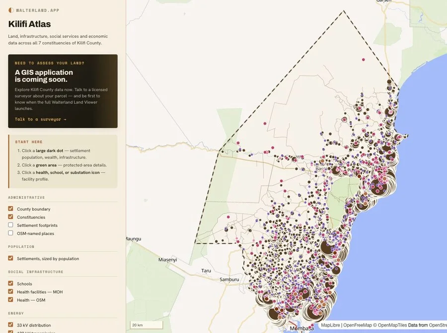
The County Government Act 2012 requires all 47 counties to prepare 10-year County Spatial Plans. These plans guide land use, infrastructure investment, and development control. We have partnered with Kilifi County to deliver their Spatial Data Infrastructure, including land parcel data, school mapping, and health facility locations. Our experience with county-scale GIS implementation means we understand the legal requirements, data standards, and institutional challenges unique to Kenya.
GIS Solutions
County Spatial Planning
10-year County Spatial Plans as required by the County Government Act 2012. Land use zoning, infrastructure planning, and development control systems for county governments
QGIS Implementation and Training
Professional-grade GIS without ESRI licensing costs. We set up QGIS workstations, configure PostGIS databases, and train your staff to maintain the system independently
Web-GIS Portals
OGC-compliant web mapping applications. Allow stakeholders to view and query spatial data through any web browser. Includes WMS and WFS services
Precision Agriculture Mapping
Soil mapping, yield zone analysis, and variable rate application maps. Help large-scale farms optimize inputs and increase productivity through spatial analysis
NGO M&E Systems
Monitoring and Evaluation systems with spatial components. Track project interventions, beneficiary locations, and impact areas. Map-based dashboards for donor reporting
Asset and Infrastructure Mapping
Digital inventory of roads, water points, power lines, schools, and health facilities. Essential for county planning, maintenance scheduling, and resource allocation
How GIS Implementation Works
Needs Assessment and Scoping
We meet with your team to understand your goals, legal requirements, existing data, and technical capacity. For counties, this includes reviewing spatial plan mandates, CIDP requirements, and reporting obligations. For NGOs, we assess donor reporting needs and M&E frameworks. For farms, we discuss precision agriculture goals. The output is a clear scope of work, timeline, and budget proposal.
Data Inventory and Acquisition
We inventory your existing data (spreadsheets, shapefiles, paper maps, survey records). We identify gaps and acquire missing datasets from government sources, satellite imagery providers, or field surveys. For counties, this often includes land parcel data from the Ministry of Lands, administrative boundaries from IEBC, and infrastructure inventories from county departments.
System Design and Setup
We design the GIS architecture based on your needs. This includes setting up QGIS workstations, configuring PostGIS spatial databases, establishing data standards and naming conventions, and creating templates for map production. For web-GIS, we deploy GeoServer for data sharing and build custom web portals for public access.
Data Migration and Cleaning
We migrate existing data into the GIS, clean errors, standardize formats, and build spatial relationships. This is often the most time-intensive phase. County land records, for example, may exist in multiple formats across different offices. We consolidate everything into a single, authoritative spatial database with proper quality control.
Staff Training Program
We train your team to use and maintain the GIS independently. Training is hands-on and tailored to your workflows. Topics include QGIS basics, spatial data editing, map production, database queries, and troubleshooting. We provide training manuals in English and Swahili. Training typically runs 5-10 days depending on staff technical background and system complexity.
Ongoing Support and Maintenance
After implementation, we provide support contracts covering software updates, troubleshooting, data updates, and refresher training. Most clients opt for 1-year support contracts initially, then transition to on-demand support as internal capacity grows. Our goal is self-sufficiency, not dependency. We build systems your team can maintain without us.
Legal Requirements for County Governments
County Spatial Plans (10-year mandate)
The County Government Act 2012 requires all 47 counties to prepare 10-year County Spatial Plans. These plans guide land use zoning, infrastructure investment, and development control. Without a spatial plan, counties cannot legally approve development applications or allocate land. GIS is the foundation for creating, implementing, and updating these plans.
County Integrated Development Plans (CIDP)
The County Government Act requires each county to prepare a 5-year CIDP. This plan must include spatial components showing where projects and services are located. Counties must submit CIDPs to the Council of Governors (CoG) and the Commission on Revenue Allocation (CRA). GIS enables counties to create maps showing project locations, beneficiary distribution, and service coverage.
Land Information Management Systems (LIMS)
Counties are responsible for county spatial planning and development control. This requires maintaining accurate land records, parcel boundaries, and land use classifications. A GIS-based LIMS integrates data from the Ministry of Lands, county surveys, and development applications into a single system for land administration and revenue collection.
Infrastructure Asset Management
Counties must maintain roads, water systems, health facilities, and other public infrastructure. The Public Finance Management Act requires counties to maintain asset registers. GIS provides a spatial asset register showing what infrastructure exists, its condition, maintenance schedules, and budget requirements. Essential for planning repairs and allocating resources efficiently.
Reporting to National Government
Counties must submit regular reports to the Controller of Budget, Auditor General, and national ministries. Many reporting requirements have spatial components, such as service coverage, project locations, and revenue collection by ward. GIS enables counties to generate compliant reports with maps and spatial statistics showing progress against development targets.
Technology and Approach
QGIS for desktop GIS, PostGIS/PostgreSQL for spatial databases, GeoServer for web services, and Leaflet/OpenLayers for web mapping. All open-source, all OGC-compliant. We focus on building internal capacity so your team can maintain systems independently after implementation.
Common Questions About GIS
What is GIS and why do we need it? +
GIS is software that connects data to maps so you can see patterns and make better decisions. If your organization manages things across geography, like land, infrastructure, health facilities, or farm fields, GIS helps you see where things are, identify gaps, and plan improvements. For example, a county can map schools and immediately see which wards lack educational facilities. An NGO can overlay project sites with poverty data to target interventions. GIS turns spreadsheets into visual intelligence.
How much does county GIS implementation cost? +
County GIS implementation typically ranges from KES 3 million to KES 15 million depending on scope, data complexity, and number of staff trained. This includes system setup, data migration, staff training, and 1-year support. Annual support contracts range from KES 500,000 to KES 2 million. Using QGIS eliminates software licensing costs, which can save KES 1-2 million per year compared to ESRI ArcGIS. We provide detailed proposals after needs assessment.
Do we need expensive software like ArcGIS? +
No. For most use cases in Kenya, QGIS delivers professional GIS capabilities at zero licensing cost. QGIS is open-source, supports international standards, and reads ESRI formats. We have implemented QGIS for Kilifi County and multiple development projects with excellent results. ESRI ArcGIS costs approximately KES 120,000 per user per year. For a county with 10 staff, that is KES 1.2 million annually, forever. QGIS is free. The savings fund better data and training. We recommend ESRI only when mandated by partners or for highly specialized extensions.
How long does GIS implementation take? +
Implementation timelines vary by scope. A basic county GIS with essential datasets and 5 trained staff takes approximately 3-6 months. A full County Spatial Plan with comprehensive land use mapping and public participation takes 12-18 months. NGO M&E systems typically take 2-4 months. Precision agriculture mapping for a single farm can be completed in weeks. We provide realistic timelines in our proposals based on your specific requirements and data availability.
What training is required for our staff? +
GIS training is hands-on and tailored to your workflows. Basic QGIS training takes 5 days and covers map production, data editing, and simple analysis. Advanced training (spatial databases, web-GIS, custom scripting) takes an additional 5-10 days. We train in English or Swahili and provide user manuals. Staff do not need prior GIS experience, but basic computer skills are essential. Most county staff become proficient GIS users within 3-6 months of implementation.
Can GIS help with donor reporting? +
Yes. GIS is excellent for donor reporting because it shows project impact visually. Instead of tables, you can show maps of project sites, beneficiary locations, and service coverage. Many donors, including USAID, World Bank, and EU, require spatial data in project reports. GIS enables you to generate maps showing baseline conditions, project interventions, and outcomes. For M&E systems, GIS can track progress over time and demonstrate impact geographically, making reports more compelling and compliant with donor requirements.
Need Enterprise GIS or County Spatial Planning?
County GIS implementation typically ranges KES 3M-15M (system setup, training, 1-year support). Annual support contracts KES 500K-2M depending on scale. QGIS training: KES 15,000-30,000 per person. Contact us for project-specific proposals.