Protect Your Land Investment
A cadastral survey is the official measurement and mapping of your land boundaries. It is the legal foundation of secure land ownership in Kenya. Our ISK-registered surveyors physically visit your property, use precision GNSS equipment to measure boundary corners, install permanent concrete beacons at each corner, verify measurements against Registry Index Map (RIM) records, prepare detailed survey plans, and submit everything digitally through the Ardhisasa platform to the Land Registry and County Surveyor for approval. Without a proper cadastral survey, your title deed cannot be issued and your boundaries have no legal standing.
Boundary security matters in Kenya because land fraud costs buyers millions of shillings every year. Fake title deeds, boundary manipulation, encroachment, and double-selling are unfortunately common. A proper cadastral survey by an independent, ISK-registered surveyor who is not connected to the seller helps protect your investment. It provides legally binding documentation that stands up in court if disputes arise. Whether you are buying your first plot, subdividing inherited family land, resolving boundary disputes with neighbors, or developing sectional titles for apartments, our cadastral surveys provide the precision and legal compliance you need.
Our Cadastral Survey Services
Title Deed Surveys
Official boundary surveys for new title deed applications submitted through Kenya's Ardhisasa digital land registry platform
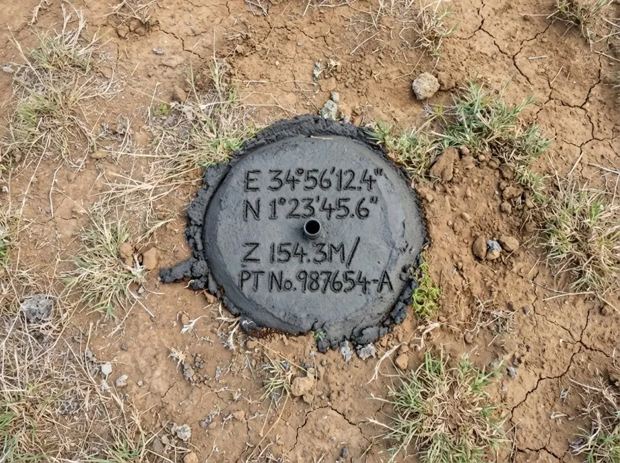
Boundary Demarcation & Beaconing
Physical marking of property boundaries with permanent concrete beacons at corners and boundary points
Land Subdivision & Mutation
Splitting large parcels into smaller plots with new individual titles. Includes PPA approval and Ardhisasa submission
Land Amalgamation
Combining two or more adjacent plots into one larger parcel with a single title deed
Sectional Property Surveys (Apartments)
Individual title deeds for each apartment or condo unit in your building. Required by the Sectional Properties Act 2020. Each unit gets a separate title with shared common areas.
Wayleave & Easement Surveys
Right-of-way surveys for utilities (power lines, water pipes, roads) across private land. Ensures fair boundaries and compensation verification
Dispute Resolution
Independent surveys to resolve boundary disagreements with legally binding beacon certificates
Our Survey Process
Site Visit & Consultation
We visit your property to assess requirements, verify existing documentation, and provide a detailed quote
Registry Verification
We verify property details with Land Registry and obtain Registry Index Map (RIM) for boundary confirmation
Field Survey
Our ISK-registered surveyors conduct precise measurements using CORS-enabled GNSS and total stations
Data Processing & Plan Preparation
Survey data is processed and verified to ensure accuracy. Detailed survey plans are prepared according to government standards.
Submission & Approval
Plans are submitted digitally through Ardhisasa platform to relevant authorities (Land Registry, County Surveyor) for approval
Legal Framework for Cadastral Surveys in Kenya
Land Registration Act 2012
Establishes how land is registered and title deeds are issued in Kenya. Requires all land transactions to be supported by cadastral surveys prepared by licensed surveyors and submitted through approved channels.
Survey Act (Cap 299)
Governs the practice of land surveying in Kenya. Only surveyors registered with the Institution of Surveyors of Kenya (ISK) can legally prepare cadastral plans for submission to the Land Registry. Unauthorized surveys are invalid and will be rejected.
Physical and Land Use Planning Act 2019
Requires planning approval before subdividing land. County Physical Planning Officers must approve subdivision plans before the Land Registry can process new title deeds. Ensures developments comply with zoning regulations and infrastructure requirements.
Sectional Properties Act 2020
Governs how apartments and condominiums can be individually titled. Requires detailed cadastral surveys showing each unit's exact boundaries, floor area, and shared common areas. Essential for property developers creating sellable apartment units.
Ardhisasa Digital Platform Requirements
Kenya's official digital land registry platform launched in 2021. All cadastral surveys must now be submitted digitally through Ardhisasa. Paper submissions are no longer accepted in most counties. Surveyors must be registered Ardhisasa users with valid credentials to submit plans on behalf of clients.
Common Questions About Cadastral Surveys
What is a cadastral survey? +
A cadastral survey is an official measurement and mapping of land boundaries by a licensed surveyor. It involves physically visiting the property, measuring boundary corners with precision GPS equipment (GNSS), installing permanent concrete beacons at corners, preparing detailed survey plans showing dimensions and coordinates, verifying measurements against government records (Registry Index Map), and submitting everything to the Land Registry through the Ardhisasa digital platform. The result is a legally recognized document that defines your property boundaries and enables title deed issuance or land subdivision.
How long does a cadastral survey take? +
Timelines vary by property complexity and government processing speed. Typical schedule: Site visit and quotation (1-3 days), Registry verification and RIM search (3-7 days), field survey (1-2 days for most residential plots), data processing and plan preparation (5-10 days), government submission and approval through Ardhisasa (2-8 weeks depending on county and any revisions needed). Total time from start to approved survey plan typically ranges from 6 weeks to 3 months. Rush services available for urgent cases.
Why do I need an ISK-registered surveyor? +
Kenyan law requires all cadastral surveys for title deeds to be prepared and signed by a surveyor registered with the Institution of Surveyors of Kenya (ISK). The Land Registry will reject any survey not prepared by a licensed surveyor. ISK registration means the surveyor has met education requirements (typically a university degree in land surveying), passed professional exams, completed practical training, maintains professional indemnity insurance, and follows the ISK Code of Professional Conduct. Using an unlicensed surveyor will cost you time and money when your survey is rejected.
What happens if my neighbor disputes the boundary? +
Boundary disputes are unfortunately common. If a neighbor challenges your boundary during or after the survey, several options exist: First, the surveyor can arrange a joint site meeting with both parties to explain the measurements and show government records (RIM). Second, both parties can agree to a new jointly witnessed survey with each party's surveyor present. Third, if agreement fails, either party can file a land dispute case at the Environment and Land Court. Our ISK-registered surveyors can provide expert testimony and beacon certificates (legally binding documentation of boundary positions) if court proceedings become necessary. Prevention is best: always inform neighbors before starting a survey.
How much does a cadastral survey cost in Kenya? +
Costs depend on several factors: property size (larger plots take more time), location (remote areas cost more due to travel), terrain difficulty (steep slopes or dense vegetation slow work), accessibility (can vehicles reach the site), county requirements (some counties have additional submission requirements), and survey complexity (simple boundary or subdivision). Typical ranges: Small residential plot (1/8 to 1/2 acre): KES 50,000 to 80,000. Standard residential plot (1 to 5 acres): KES 80,000 to 150,000. Large agricultural land (5+ acres): KES 150,000 to 300,000 or more. Subdivision surveys cost more because each new plot requires separate calculations and plans. Contact us for accurate pricing based on your specific property.
What documents do I need for a survey? +
Bring or email us copies of: Original title deed or certified copy from Land Registry (essential, shows legal ownership and parcel number), National ID or Passport (proof of identity for survey instructions), Sale agreement if purchasing (confirms you have authority to commission survey), Previous survey plans if available (helps identify existing beacons), Registry Index Map (RIM) if you have it (we can obtain this if you do not), Location sketch or GPS coordinates (helps us find the property, especially in areas without formal addresses). If you are missing documents, we can help obtain certified copies from the Land Registry in Nairobi, Mombasa, or your local county Lands Office.
Ready to Secure Your Land Title?
Cadastral survey costs typically range from KES 50,000-200,000 depending on property size, location, terrain, and accessibility. Contact us for accurate pricing based on your specific requirements.